This course is designed for beginner level learners on application of open source software's photogrammetric tools to analyze drone acquired images. It begins with the foundational principles of photography and extends to image matching, image orientation, quality control and production of ortho-photos.
This course is designed to introduce the basic skills and knowledge operating drones in the open category. The course contains both conceptual and practical components.
It is primarily designed for learners with little or no knowledge of aspects of flying a small quadcopter drones. It is a starting point for those who wish to move onto analysis and mapping of data acquired from drones.
This course will deal with the data dissemination system called EUMETCast, or globally referred to as GEONETCast. This low cost data dissemination system allows free near real time satellite data reception from a range of satellites and associated products from various data providers. The focus of this course will be on system setup for African users. The course will elaborate on the system requirements like parabolic antenna, LNB and DVB-S2 configuration / antenna pointing, service registration, different types of data received and the necessary data management. An introduction will be provided on the visualization of a number of satellite images from geostationary satellites (like MSG) and polar orbiting satellites (like METOP) as well as a range of land and atmosphere products. Use is made of free and open tools for image import and processing.
The figure below shows the parabolic antenna situated on the Mekelle University compound (near I-GEOS) and a schematic layout of the EUMETCast system configuration. Note the EUMETCast Africa service, which is the system further discussed during the course.

The purpose of this course is to provide participants with the background and knowledge necessary to use and apply environmental data currently delivered through satellite based communication systems as well as freely available relevant information which can be retrieved from online internet resources.
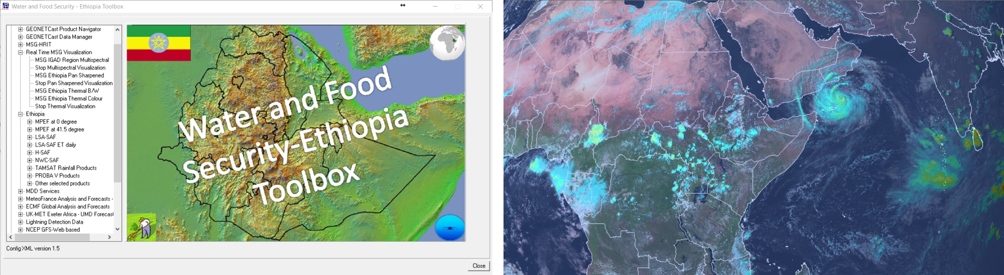
The WFS-Ethiopia Toolbox provides an open and flexible integrated solution to manage the EUMETCast-GEONETCast data stream, data derived from internet resources, etc. and import of the various image types and data products and bring them together in a common GIS and RS environment for further processing.
The main objective of the Toolbox is to allow the user, who operates a EUMETCast – GEONETCast ground receiving station to easily manage the incoming data stream and to import the data into a common freeware GIS-RS environment for further analysis, in this case using the functionality of ILWIS version 3.7.2 or higher. This toolbox version allows import of various data sources relevant for water and food security analysis for Ethiopia through a Graphical User Interface (GUI).
The purpose of this course is to provide participants with the knowledge necessary to conduct the necessary data translation, required to import the geo-information in raster and vector formats into common used free and open GIS/RS tools, like QGIS and ILWIS.
The course deals with an introduction to MS DOS as most participants might require an update on the use of the command line tools available under Windows. Subsequently the Geospatial Data Translation Library (GDAL) is introduced and raster as well as vector data, consisting of various formats (NetCDF, HDF5, JPEG, etc.) have to be imported in a common free GIS/RS tool. Also attention is given to the extraction of the data set Meta Data descriptions as well as the used of raster data which is having a certain projection.
Subsequently QGIS is introduced. After a primer on the basic use and functionality of QGIS, participants will work with raster and vector data as well as those available through web mapping services. The lesson ends with a case study dealing with a multi-criteria analysis for locating photovoltaic power plants in Addis Ababa, Ethiopia.
Finally the course is dealing with the use of ILWIS. Also during this lesson participants will be introduced to the functionality of ILWIS, dealing with the overall menu and the map window menu items. The lesson concludes with exercises demonstrating the application of various operations and map calculations and the use of scripts.
![]()
The focus of this course is on the retrieval and use of the free satellite data acquired by medium resolution earth observing satellites like Landsat, Aster and the Sentinel series of satellites. Based on an inventory using the Observing Systems Capability Analysis and Review Tool (OSCAR) and the ITC Satellite and Sensor Database, images from online archives will be retrieved and processed using free and open software tools.
An example is provided in the figure below showing a python based utility developed to handle the import and pre-processing of Sentinel 1-3 data and respective use in QGIS and ILWIS. The example presented on the right hand side here is a Sentinel 1 image overlaid on Google Earth.
